Easy Hikes - Oberstdorf
- Pause to Play

- Oct 11, 2025
- 9 min read
Contents
Instant download, no email.
The mountains don't always demand a summit. Sometimes they invite you to be present — to walk without a punishing pace, breathe the alpine air, and find a rhythm that feels like coming home.
This collection of Easy Hikes - Oberstdorf is for those days: gentle paths with wide horizons — sun-drenched meadows, quiet valleys, effortless viewpoints.
These are hikes you can say “yes” to any day. Slow down, look around, and enjoy the simple joy of moving through a beautiful place. Start below, pick a trail, and go.

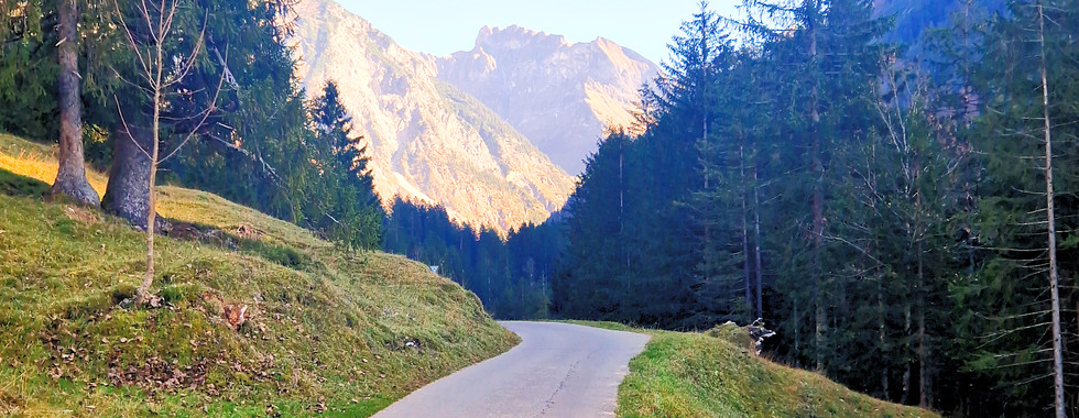
An Effortless Alpine Walk: Öschwiesen Meadows (Oberstdorf)
Some days are for breathing out, not pushing. This sunny loop across Öschwiesen gives you wide-open views, easy ground, and that pleasant “let’s just stroll” feeling—perfect for a relaxed afternoon.
At a glance
Distance: 5.1 km
Time: ~2 h (easy pace)
Elevation: ~42 m total gain
Difficulty: easy, suitable for all fitness levels
Surface: mostly gravel with short paved sections
Family-friendly: yes — stroller-friendly
How it flows
Start on Gertrud-von-le-Fort-Weg, cross Ziegelbachbrücke, then drift gently toward Karatsbichl before looping back across the meadows. Wayfinding is simple, the profile stays mellow, and the views stay big.

Pause points
Ziegelbachhütte — quick snack in the fields
Café-Restaurant Karatsbichl — sunny terrace when you’re ready to linger
Light & shade
These south-side meadows catch generous sun; even a late-afternoon start feels inviting. In late autumn the air turns crisp fast once the sun dips—pack a light layer just in case.
Why it’s a Pause to Play pick:
simple route, roomy scenery, zero stress. If you want nature without the climb, this is the Oberstdorf “yes” you can say on any easy day.

Through the Breitach Gorge to Engenkopf (Easy–Moderate Loop)
Some walks wake you up with sound. This one starts in the Breitachklamm—cool, dim, and thunderous—then opens onto sunny meadows and the quieter slopes of Engenkopf. Wet rock, green light, big views: a short route with lots of contrast.
At a glance
Distance: 3.7 km
Time: ~2 h
Elevation gain: ~157 m
Difficulty: easy to moderate (technically simple, a bit of up)
Surface: gravel + short asphalt sections
Toilets: at the Breitachklamm entrance (Tiefenbach)


How it flows
Start at Tiefenbach / Eingang Breitachklamm → walk the gorge to the upper exit → cross Zwingsteg → climb to Engenkopf (option: take the signed Rundweg Engenkopf) → descend via Alpe Dornach and Hochstatt → return toward the Breitachklamm / Tiefenbach entrance. Wayfinding is well signed throughout.
Why it’s lovely in any weather
The gorge is always damp and shaded, which makes it refreshing on hot days—and dramatic in the rain as water volume rises. Expect spray and slick rock; that’s part of the show.
Skills & gear
No alpine experience needed, but bring sure-footedness (short steeper bits, small steps). Wear sturdy shoes with tread, pack a light shell; trekking poles optional.
Family & accessibility
Strollers and wheelchairs aren’t possible here (even foldable models). A child carrier works if you’re used to it.
Pause points
Alpe Dornach (food/terrace)
Gasthof Breitachklamm near the entrance
Variants nearby: Hintere Enge I & II, Osterbergalpe, Berggasthof Sesselalpe.

Good to know
Trails around Engenkopf stay a little off the busiest routes—botany and geology fans will love it; locals still call it a small insider tip. Please keep the spirit of “Zämed duss – Zusammen draußen”: share the paths with care.
Why It’s a Pause to Play Pick:
This hike offers two completely different worlds in one short loop. You get the thrill and natural spectacle of a famous gorge, followed by the quiet satisfaction of discovering a hidden gem. The paths around Engenkopf are still considered an insider's tip, offering peaceful moments just steps away from a bustling attraction. It’s a perfect mix of drama and tranquility.

A Gentle Oytal Valley Walk (Oberstdorf)
Some days aren’t about pushing — they’re about being out there. This easy valley walk lets you slip into Oytal’s quiet rhythm: forest shade, a steady river, long views of the Allgäu peaks. No rush. Just movement, breath, and space.
At a glance
Distance: 10.1 km
Time: ~3 h 30 min (unhurried)
Elevation: ≈190 m total gain
Difficulty: easy–moderate (no exposure)
Terrain: paved lanes, compact gravel, short pebbly bits
Best season: May–November


How it flows
Start at Mühlenbrücke. Set an easy pace along Dr.-Hohenadl-Weg and Oytalstraße as the valley opens. Wayfinding is simple; the grade stays friendly. Turn back via Kühberg and the Skisprung Arena to re-enter Oberstdorf — a gentle loop that feels grounded from first steps to last.
Pause points
Café Jägerstand — coffee to ease into the day
Berggasthaus Oytalhaus — lunch stop + accessible restrooms
Erdinger Sportalp — a relaxed finish by the ski jump
Playful return (optional)
After 15:00, Oytalhaus rents kick scooters for the glide back toward town. It’s light, fun, and kind to tired feet. (Groups 15+: call ahead.)
If you’ve got more in the tank
Carry on toward Käseralpe for closer views of Höfats and the Stuibenfall waterfall. It adds time and distance — decide with your body, not your ego.
Shared trails, good manners
You’ll cross active pastures. Keep dogs leashed near cattle, close gates, and pack out waste. Leave the valley as calm as you found it.
Tip: Start early for soft light and quieter paths. A light shell + water is enough on most days.
Oytal is a narrow valley, so in October–November the sun sits low and much of the route stays in cool shade for long stretches. It can feel several degrees colder than in the village, and late in the day the temperature drops fast. Expect damp leaves, slick pebbles, and the occasional thin film of frost in the morning.
Pack for cozy: a light mid-layer + windproof shell, thin gloves, and a beanie make this an all-comfort walk. Warm tea in a flask = instant morale boost. If it looks icy, shorten the loop and keep your pace relaxed.
Why it’s a Pause to Play pick:
It delivers the grandeur of the Alps without the grind. You get huge mountain scenery on a path that lets you breathe, not gasp. The optional kick scooter return is pure, simple fun—a perfect nod to the 'play' in our name. This is maximum reward for mindful effort. A classic valley walk that reminds you that sometimes, the best path is the one that simply flows.

Into the Stillach Valley: Oberstdorf → Birgsau → Einödsbach (loop with bus back)
Some walks slow the mind while the scenery gets bigger. This valley route follows the Stillach south from Oberstdorf past the ski-flying arena and meadows to the quiet hamlets of Birgsau and Einödsbach—a long, gentle day with plenty of “look up and breathe” moments.
At a glance
Distance: 13.2 km
Time: ~4 h 30 min (easy pace)
Elevation gain: ~354 m total
Grade: easy valley walk (no exposure)
Surface: gravel & asphalt
Type: marked hiking pathAll figures per the local tour sheet.


How it flows
From Oberstdorf drift across Öschwiesen to Renksteg, then follow the Stillachdammweg toward the Skiflugschanze. Continue via Schwand and Ringang to the Fellhornbahn Talstation, cross the Stillachsteg, then on past Anatsstein to Birgsau and finally Einödsbach. Return the easy way: bus from Birgsau back to Oberstdorf. Wayfinding is straightforward the whole way.
Pause points (food & coffee)
Fellhornstuben; Gaststätte-Café Faistenoy (near the gondola base)
Landhaus Adler – Birgsau; Hotel-Alpengasthof Birgsauer Hof
Berggasthof Einödsbach (deepest point of the walk)Listed by the official tour sheet.
Facilities & transit
Public restrooms: at the Skiflugschanze and the Fellhornbahn Talstation.
Bus: Oberstdorf ↔ Stillachtal line, with stops at Renksteg, Skiflugschanze, Fellhornbahn/Faistenoy, and Birgsau/Eschbach—handy for shortening or closing the loop.
When to go & what to bring
This is a valley tour with mixed surfaces; conditions change fast in the Alps. Pack a light shell, water, and snacks; sturdy shoes with tread make it nicer underfoot. The official note: tours assume normal conditions—if unsure about your fitness, experience, or gear, consider skipping or joining a professional guide.
Why It’s a Pause to Play Pick:
This is the perfect "small big adventure." It delivers the satisfaction of covering serious ground and arriving "somewhere else," all with the low-stress comfort of a bus ride back. If you want to feel like you’ve truly ventured into the mountains without the grueling effort, this journey into Stillachtal is your answer.
Shared trails, good manners
You’ll pass hay meadows and past ure. Keep dogs leashed near cattle, close gates, and leave the valley as calm as you found it.

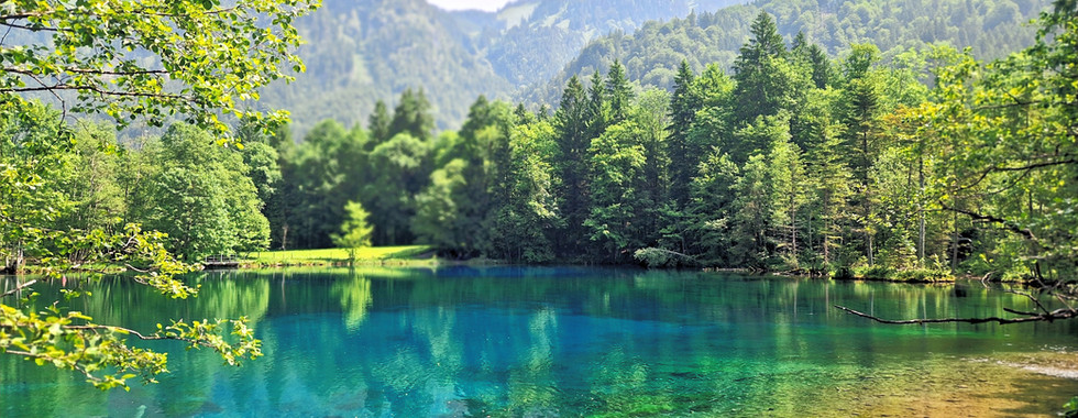
Trettachtal Valley Day Walk (Oberstdorf) – Meadows, Cafés & Christlessee
Some days you just want to drift through a wide valley and let the scenery do the work. This long but gentle tour threads the Trettachtal from Oberstdorf along quiet lanes and meadow paths, with plenty of places to pause—and the cobalt glow of Christlessee as a highlight.
At a glance
Distance: 14.5 km
Time: ~5 h (easy pace)
Elevation gain: ~177 m
Difficulty: easy terrain, moderate by length
Setting: valley walk • gravel with short asphalt sections
Shorten it: hop the mountaineer bus that shuttles Oberstdorf ↔ Spielmannsau several times daily.


How it flows
Start at Mühlenbrücke and settle into the rhythm: Jägerstandweg → Gruben → Dietersberg → Mumme → Gottenried → Spielmannsau → Truppersoy → Christlessee → Golfplatz → Renksteg → Lorettokapellen. Wayfinding is clear; gradients stay friendly.
Pause points (food & coffee)
A valley made for lingering: Café Jägerstand, Café Gruben, Berggasthof Riefenkopf, Mummestüble, Berggasthof Spielmannsau, Café-Restaurant Christlessee, Brotzeitstüble Haseltopf, Café Gebrgoibe.
Why it’s special
At Christlessee, countless springs keep the water at ~4 °C year-round, so the lake famously doesn’t freeze—even in winter. The whole route feels close to nature, with long views and quietly managed pastures.
Skills & comfort
No alpine experience or head for heights needed; sure-footedness is helpful on mixed surfaces. If legs get heavy late in the day, use the bus from Spielmannsau to trim the finish.
Season & light
This valley walk runs well from May–November. In autumn, shade lingers and temperatures can sit a few degrees cooler than in town—pack a light layer and keep an eye on damp leaves and pebbles.
Shared trails, good manners
You’re crossing working meadows. Keep dogs on a lead near cattle, close gates, and carry out waste—the local spirit of “Zämed duss – Zusammen draußen” is about sharing the outdoors with care.
Why it’s a Pause to Play pick:
This hike is the definition of flexible freedom. It offers a full day of immersive scenery and gentle challenge, but with an easy way out when you're ready to stop. You can make it as long or as short as you feel, enjoying a wealth of peaceful nature and charming rest stops. It’s a perfect adventure that adapts to your energy, not the other way around.
Tip: Bus option (Spielmannsau & Christlessee)
You don’t have to walk it all both ways. The Oberstdorf ↔ Spielmannsau mountaineer bus runs through the valley with a handy Christlessee stop. Ride out in the morning and walk back, or walk south and hop the bus for an easy return. Check today’s timetable and stop names before you go.

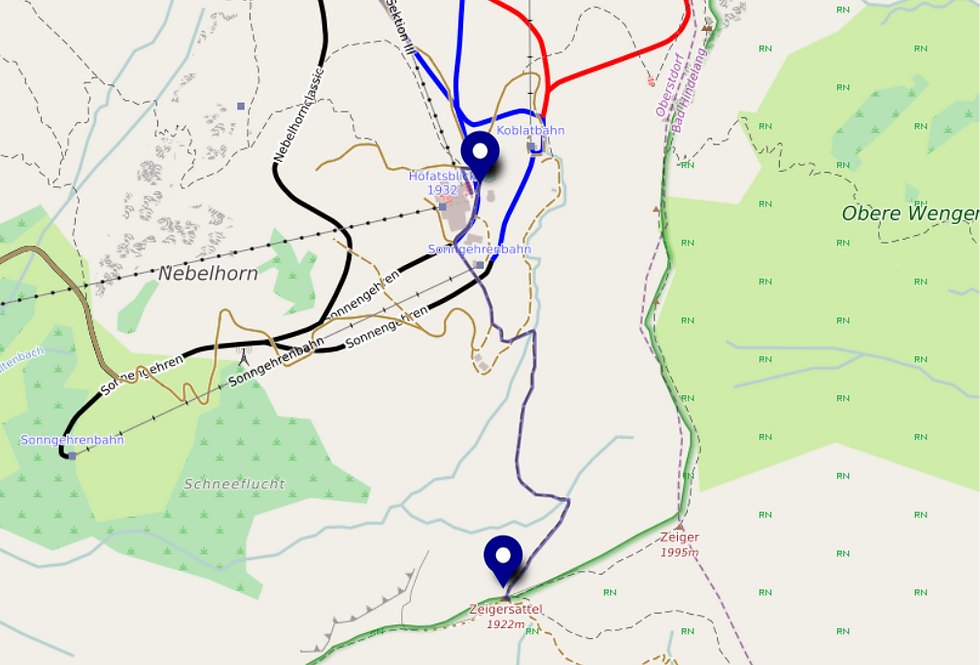
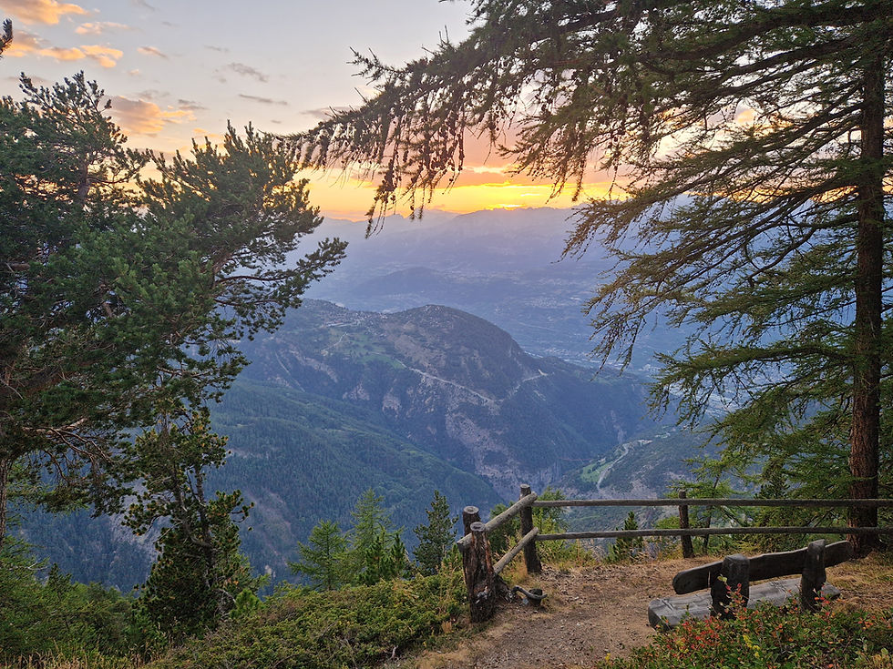
Höfatsweg: A Short Ridge-View Walk from Höfatsblick (Nebelhorn)
Some outings are made for family days: simple paths, big horizons, and a little nature-spotting along the way. This there-and-back walk from the Nebelhornbahn top area to the Zeigersattel is exactly that—light on effort, generous on views.
At a glance
Route: Höfatsblick (cable-car top) → Zeigersattel → return the same way
Time: ~1 h 30 min
Difficulty: easy (yellow; well-maintained)
Terrain: compact earth & gravel, short paved/pebbly sections
Setting: mid-mountain meadows with panoramic viewpoints
Family-friendly: yes (no exposure; gentle grades)


How it flows
From Bergstation Höfatsblick, pass the small playground and turn right at the first wooden sculpture. A brief descent on gravel leads toward the winter Koblat chairlift base. From here the trail eases, traversing to a signed viewpoint and onward with a gentle climb to the Zeigersattel. Return to the station along the same path.
Why you’ll love it
At the saddle, the panorama opens wide: the elegant Höfats across the Oytal with its steep flanks and knife-edge ridges; the rocky main crest with Trettachspitze and Mädelegabel to the southwest. Below, the pastures of Hintere Seealpe unfurl toward the picture-perfect Seealpsee. On quiet days you might spot marmots or chamois sharing summer meadows with grazing cattle.
Meadow magic (flora)
This is flower country. Depending on season, you may find pasqueflowers, several gentian species, and the dark, vanilla-scented black vanilla orchid (Schwarzes Kohlröschen). Look closely, photograph freely—don’t pick.
Gear & season
Footwear: sturdy, ankle-high shoes with grip
Layers: windproof/rain shell; extra warmth if weather turns
Sun & fluids: sunscreen, hat, and enough water on warm days
Respect the trail
Shortcuts off the marked path erode turf and disturb pastureland and wildlife. Stay on signed routes, close gates, keep dogs leashed around cattle, and leave plants where they grow—many are rare or protected (some are toxic).
Food & pause points
Marktrestaurant at the top station (easy post-walk meal)
Edmund-Probst-Haus (classic alpine stop near Höfatsblick)
Why it's a Pause to Play pick:
This is the ultimate mountain shortcut, delivering an immense alpine panorama for a wonderfully small amount of effort. The cable car does all the heavy lifting, leaving you free to simply stroll, soak in the views of the iconic Höfats, and maybe even spot a marmot. It’s a hike that’s all reward—a perfect pocket-sized adventure that proves you don’t always have to climb a summit to feel on top of the world.
Planning easy hikes Oberstdorf? Start with a mellow valley loop, grab the 1-Day Map, and enjoy big views without the grind. Pause. Play. Repeat.
Info only; conditions change. You’re responsible for your choices and gear. Emergency: 112.
Jump to:
Challenging Hikes (coming soon)
Via Ferrata (coming soon)
Biking & E-Biking (comming soon)
Rainy Days (comming soon)


Comments